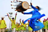
This lesson is designed for World Geography teachers to teach standard 3 …
This lesson is designed for World Geography teachers to teach standard 3 about Culture to students. In the end students will be creating a video sharing their culture and showing their understanding of what culture is and what influences it has based on place, religion, etc...
his lesson uses music and art in a vocabulary study of unfamiliar …
his lesson uses music and art in a vocabulary study of unfamiliar words from the song "America the Beautiful," increasing students' vocabulary while also increasing their knowledge of U.S. geography. A discussion to activate students' prior knowledge about sights and scenery throughout the United States is followed by a read-aloud and introduction to the song "America the Beautiful," which is then sung in each session of the lesson. Students learn the meanings of the song's words through shared reading and the use of context clues and images. Students then use photographs, illustrations, and descriptive language to create a mural shaped like the United States. Finally, through pictures and words, students reflect on what they have learned. This lesson is appropriate and adaptable for any patriotic event or holiday, and many of the vocabulary strategies are adaptable for other texts or word lists, as well.
This lesson plan examines the events of the Bloodiest day in American …
This lesson plan examines the events of the Bloodiest day in American History and helps students to understand the complexities of the event. Students will use the American Battlefield Trust Antietam 360 Virtual Tour to study certain moments of the battle and analyze how the natural and man-made environment affected the maneuvers, strategies, and tactics used during the battle as well as how these factors impacted the outcome of the battle.
Word Count: 7198 (Note: This resource's metadata has been created automatically by …
Word Count: 7198
(Note: This resource's metadata has been created automatically by reformatting and/or combining the information that the author initially provided as part of a bulk import process.)
Word Count: 9323 (Note: This resource's metadata has been created automatically by …
Word Count: 9323
(Note: This resource's metadata has been created automatically by reformatting and/or combining the information that the author initially provided as part of a bulk import process.)
This first year Geography textbook takes a holistic approach to Geography by …
This first year Geography textbook takes a holistic approach to Geography by incorporating elements of physical, human and regional geography, as well as bringing in methods and perspectives from spatial information science.. This textbook applies a fundamental geographical approach to understanding our globally changing world by looking at local processes which are linked to larger global processes and events. For example mining and its effects are a global issue and we can see how these unfold in BC. A further example is the recent apology to First Nation peoples on the residential school treatment, as similar events occur in the US, Ireland and Australia. Processes of urbanization, a phenomenon which people all over the globe are experiencing, can be seen in Vancouver with our discussion of the citys development. Geography students, indeed all first year students, need to be able to critically assess their own contexts and environments in order to properly engage with our continually globalizing world.
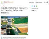
This lesson highlights the changing relationship between the city center and the …
This lesson highlights the changing relationship between the city center and the suburb in the postwar decades, especially in the 1950s. Students will look at the legislation leading up to and including the Federal Highway Act of 1956. They will also examine documents about the history of Levittown, the most famous and most important of the postwar suburban planned developments.
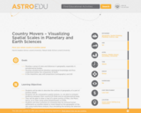
Students learn about local and planetary physical geography / geology, toponymy, planetary …
Students learn about local and planetary physical geography / geology, toponymy, planetary landing site selection and cartography. The students learn a complex process of landscape evaluation and city planning, based on the interpretation of photomaps or digital terrain models.
With e-pals, students develop real-life writing and social experiences, learn the format …
With e-pals, students develop real-life writing and social experiences, learn the format of a friendly letter and parts of an e-mail message, and discover other cultures, languages, and geographic areas.
Word Count: 55656 (Note: This resource's metadata has been created automatically by …
Word Count: 55656
(Note: This resource's metadata has been created automatically by reformatting and/or combining the information that the author initially provided as part of a bulk import process.)
Three lesson plans including classroom activities, assignments, homework, and keys. Lesson 1: …
Three lesson plans including classroom activities, assignments, homework, and keys. Lesson 1: Gift of the Nile, map, worksheet, visual literacy, Lesson 2. Barter Beer and Bread, Lesson 3. Nile, Red Sea, and Mediterranean Trade
This is a lesson that uses collaboration and technology to discuss and …
This is a lesson that uses collaboration and technology to discuss and view earth's geography and human settlements and how the landforms support life on earth. Cover image source:https://www.freeimages.com/photo/apple-1327446
This video segment adapted from NOVA features the youngest rock formations in …
This video segment adapted from NOVA features the youngest rock formations in the Grand Canyon, lava dams, and how they are subject to the eroding power of water.
Release of the film Green Book (2018) inspired renewed interest in the …
Release of the film Green Book (2018) inspired renewed interest in the experiences of African Americans when traveling in the United States during the 20th century. This inquiry-based lesson combines individual investigations with whole or small group analysis of elementary sources and visual media to investigate the compelling question: How have the intersections of race and place impacted U.S. history and culture?
No restrictions on your remixing, redistributing, or making derivative works. Give credit to the author, as required.
Your remixing, redistributing, or making derivatives works comes with some restrictions, including how it is shared.
Your redistributing comes with some restrictions. Do not remix or make derivative works.
Most restrictive license type. Prohibits most uses, sharing, and any changes.
Copyrighted materials, available under Fair Use and the TEACH Act for US-based educators, or other custom arrangements. Go to the resource provider to see their individual restrictions.