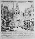
Students analyze primary sources and create a propaganda poster based on the …
Students analyze primary sources and create a propaganda poster based on the Boston Massacre.Image found on http://hdl.loc.gov/loc.pnp/ppmsc.00174The Bloody Massacre Perpetrated in King Street Boston on March 5th 1770 by a Party of the 29th Regt. Boston: Engrav’d Printed & Sold by Paul Revere, 1770. Fine Prints. Prints & Photographs Division
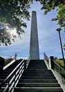
Have you ever wondered what the different places around the United States …
Have you ever wondered what the different places around the United States looks like where so many different important events happened? It can be hard to travel to find the answers and see these places. Yet with this lesson, students will need to use free images you can find to show what these locations look like now. They will be exploring the historical sites through pictures and words to hopefully truly connect to these places. Thumbnail image is an original photo taken of the Bunker Hill Monument in Boston, Massachusetts.
C3. Inquiry based lesson plan. Students explore the connection between the consumption …
C3. Inquiry based lesson plan. Students explore the connection between the consumption of sugar and the reliance of slave labor to cultivate sugar plantations. Includes multiple opportunities to explore the supporting questions and develop an argument with claims, including charts, graphs, illustrations, reading excerpts, and background information.
Learn how geography has shaped the lives of the people of Boston …
Learn how geography has shaped the lives of the people of Boston and see how different Boston’s landscape is today in this interactive activity—produced by WGBH and featuring materials from the Norman B. Leventhal Map Center at the Boston Public Library. Explore colonial Boston and the geographic and human-made features of the Shawmut Peninsula in 1723: hills, ships and shipyards, and a narrow “neck” connecting the town to the mainland.
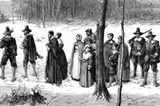
C3. Inquiry based lesson plan. Students explore how the relationship between the …
C3. Inquiry based lesson plan. Students explore how the relationship between the pilgrims and the Wampanoag changed over time. Students develop an argument with evidence about whether or not the conflicts that developed could have been avoided (from the pilgrims' and Wampanoag's perspectives). Includes pictures, maps, excerpts, supporting questions, formative, and summative assessments.
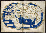
In this lesson students compare three maps, one from 1491, one from …
In this lesson students compare three maps, one from 1491, one from 1570, and one from 1794 to note differences and discus why the maps changed over time. This in turn can introduce wider discussions of exploration of the Americas. Thumbnail: World map by Martellus, British Library, CC0, via Wikimedia
Students will learn how modern day immigrants may be pilgrims in their …
Students will learn how modern day immigrants may be pilgrims in their own respect. They will learn what immigrants and pilgrims are, and be assigned to demonstrate learning about an immigrant in their ancestry.
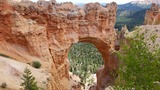
In this unit plan, students use genius hour to learn about different …
In this unit plan, students use genius hour to learn about different landforms from Utah's nations parks that were created through weathering and erosion. Students will also research explorers to learn how to use Utah's Online Library and cite ources.Thumbnail image taken by David Woodhead
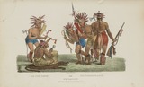
This lesson will help your students learn about the tribes of the …
This lesson will help your students learn about the tribes of the 13 colonies and the relationships they had with the European settlers. Students will be researching and creating a poster to share their tribe. "The Pipe Dance and the Tomahawk Dance of the Chippeway Tribe" by James Otto Lewis licensed under CC 1973.167.40Image Created by: James Otto Lewis
This resource is a Social Studies student activity that utilizes Utah's Online Library …
This resource is a Social Studies student activity that utilizes Utah's Online Library resources - specifically, Gale's Kids InfoBits Grades K-6 - to help students learn about the Plymouth Colony.
No restrictions on your remixing, redistributing, or making derivative works. Give credit to the author, as required.
Your remixing, redistributing, or making derivatives works comes with some restrictions, including how it is shared.
Your redistributing comes with some restrictions. Do not remix or make derivative works.
Most restrictive license type. Prohibits most uses, sharing, and any changes.
Copyrighted materials, available under Fair Use and the TEACH Act for US-based educators, or other custom arrangements. Go to the resource provider to see their individual restrictions.