A view of -- Lake Bonneville with Red Rock Pass -- is …
A view of -- Lake Bonneville with Red Rock Pass -- is presented in this media item extracted from the 22-part video series THE GEOGRAPHY OF UTAH, conceived and written by Albert L. Fisher, PhD (University of Utah). The series encompasses the political, cultural, historical and sociological geography of the state of Utah. It describes the activities, the land and the people. Much of the video material was videotaped on location throughout the state of Utah, giving the student and interested viewer valuable field trip experiences. === The water of Lake Bonneville eventually reached the rim of Red Rock Pass in northern Cache Valley and began to overflow, causing a dramatic geologic event. Red Rock Pass consisted of loose sand and gravel. Escaping water washed away this material, deepening the channel and causing the water overflow to increase rapidly. The flow of water through the Pass is estimated to have been three or four times the amount of water flowing through today's Amazon River. Red Rock Pass continued to erode for about 25 years until the water reached a layer of resistant limestone, and the lake stabilized at the Provo level, about 400 feet lower. ===
A view of -- Cache Valley cheese sign -- is presented in …
A view of -- Cache Valley cheese sign -- is presented in this media item extracted from the 22-part video series THE GEOGRAPHY OF UTAH, conceived and written by Albert L. Fisher, PhD (University of Utah). The series encompasses the political, cultural, historical and sociological geography of the state of Utah. It describes the activities, the land and the people. Much of the video material was videotaped on location throughout the state of Utah, giving the student and interested viewer valuable field trip experiences.
A view of -- Deadhorse Point -- is presented in this media …
A view of -- Deadhorse Point -- is presented in this media item extracted from the 22-part video series THE GEOGRAPHY OF UTAH, conceived and written by Albert L. Fisher, PhD (University of Utah). The series encompasses the political, cultural, historical and sociological geography of the state of Utah. It describes the activities, the land and the people. Much of the video material was videotaped on location throughout the state of Utah, giving the student and interested viewer valuable field trip experiences.
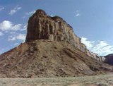
A view of -- Mesa in Canyonlands National Park -- is presented …
A view of -- Mesa in Canyonlands National Park -- is presented in this media item extracted from the 22-part video series THE GEOGRAPHY OF UTAH, conceived and written by Albert L. Fisher, PhD (University of Utah). The series encompasses the political, cultural, historical and sociological geography of the state of Utah. It describes the activities, the land and the people. Much of the video material was videotaped on location throughout the state of Utah, giving the student and interested viewer valuable field trip experiences.
A view of -- Three Gossips -- is presented in this media …
A view of -- Three Gossips -- is presented in this media item extracted from the 22-part video series THE GEOGRAPHY OF UTAH, conceived and written by Albert L. Fisher, PhD (University of Utah). The series encompasses the political, cultural, historical and sociological geography of the state of Utah. It describes the activities, the land and the people. Much of the video material was videotaped on location throughout the state of Utah, giving the student and interested viewer valuable field trip experiences.
A view of -- Starvation Reservoir, Uinta Mountains -- is presented in …
A view of -- Starvation Reservoir, Uinta Mountains -- is presented in this media item extracted from the 22-part video series THE GEOGRAPHY OF UTAH, conceived and written by Albert L. Fisher, PhD (University of Utah). The series encompasses the political, cultural, historical and sociological geography of the state of Utah. It describes the activities, the land and the people. Much of the video material was videotaped on location throughout the state of Utah, giving the student and interested viewer valuable field trip experiences.
The folk art of -- Hispanic folk and ethnic arts in Utah …
The folk art of -- Hispanic folk and ethnic arts in Utah -- is showcased. Contributed by the Utah Arts Council Folk Art Program from their HISPANIC CULTURE IN UTAH archives and the book HECHO IN UTAH, singers, dancers, musicians, boat builders, wood carvers, and ceramists are included in photos, biographies, and audio clips.
The folk art of -- J. Zumaeta and son, with her needlework …
The folk art of -- J. Zumaeta and son, with her needlework -- is showcased. Contributed by the Utah Arts Council Folk Art Program from their HISPANIC CULTURE IN UTAH archives and the book HECHO IN UTAH, singers, dancers, musicians, boat builders, wood carvers, and ceramists are included in photos, biographies, and audio clips.
The folk art of -- Santos and Luzmila Arrambide -- is showcased. …
The folk art of -- Santos and Luzmila Arrambide -- is showcased. Contributed by the Utah Arts Council Folk Art Program from their HISPANIC CULTURE IN UTAH archives and the book HECHO IN UTAH, singers, dancers, musicians, boat builders, wood carvers, and ceramists are included in photos, biographies, and audio clips.
The history of Pioneer Memorial Theatre is summarized in this media item …
The history of Pioneer Memorial Theatre is summarized in this media item extracted from the 20-part video series A PEOPLES' HISTORY OF UTAH, written and hosted by Dean L. May, PhD (University of Utah). The series provides a sweeping view of Utah's past, from its earliest known desert beginning--from its prehistory, to the pioneer era, to the transformation from territory to state, to its critical role in the world war years and beyond.
The history of Net of sagebrush fibers by archaic people is summarized …
The history of Net of sagebrush fibers by archaic people is summarized in this media item extracted from the 20-part video series A PEOPLES' HISTORY OF UTAH, written and hosted by Dean L. May, PhD (University of Utah). The series provides a sweeping view of Utah's past, from its earliest known desert beginning--from its prehistory, to the pioneer era, to the transformation from territory to state, to its critical role in the world war years and beyond.
The history of Scofield Mine Disaster funeral is summarized in this media …
The history of Scofield Mine Disaster funeral is summarized in this media item extracted from the 20-part video series A PEOPLES' HISTORY OF UTAH, written and hosted by Dean L. May, PhD (University of Utah). The series provides a sweeping view of Utah's past, from its earliest known desert beginning--from its prehistory, to the pioneer era, to the transformation from territory to state, to its critical role in the world war years and beyond.
The history of -- Southern Paiute range in relief map -- is …
The history of -- Southern Paiute range in relief map -- is summarized in this media item extracted from the 20-part video series A PEOPLES' HISTORY OF UTAH, written and hosted by Dean L. May, PhD (University of Utah). The series provides a sweeping view of Utah's past, from its earliest known desert beginning--from its prehistory, to the pioneer era, to the transformation from territory to state, to its critical role in the world war years and beyond.
The history of -- Beaver County -- is examined in an article …
The history of -- Beaver County -- is examined in an article provided as a PDF document. This article is extracted from the book UTAH HISTORY ENCYCLOPEDIA, published in celebration of Utah's Centennial (1996) and edited by Allan Kent Powell. Over two hundred contributors wrote about the individuals, organizations, locations, institutions, and topics important to Utah history.
The history of -- Bureau of Land Management -- is examined in …
The history of -- Bureau of Land Management -- is examined in an article provided as a PDF document. This article is extracted from the book UTAH HISTORY ENCYCLOPEDIA, published in celebration of Utah's Centennial (1996) and edited by Allan Kent Powell. Over two hundred contributors wrote about the individuals, organizations, locations, institutions, and topics important to Utah history.
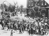
An historical image of -- Chinese community float, Pioneer Days 1897 -- …
An historical image of -- Chinese community float, Pioneer Days 1897 -- is provided in conjunction with the articles from the book UTAH HISTORY ENCYCLOPEDIA, published in celebration of Utah's Centennial (1996) and edited by Allan Kent Powell. The Utah State Historical Society generously granted rights to display hundreds of images from their collections.
The history of -- Clarion Colony -- is examined in an article …
The history of -- Clarion Colony -- is examined in an article provided as a PDF document. This article is extracted from the book UTAH HISTORY ENCYCLOPEDIA, published in celebration of Utah's Centennial (1996) and edited by Allan Kent Powell. Over two hundred contributors wrote about the individuals, organizations, locations, institutions, and topics important to Utah history.
The history of -- Clyde, George Dewey -- is examined in an …
The history of -- Clyde, George Dewey -- is examined in an article provided as a PDF document. This article is extracted from the book UTAH HISTORY ENCYCLOPEDIA, published in celebration of Utah's Centennial (1996) and edited by Allan Kent Powell. Over two hundred contributors wrote about the individuals, organizations, locations, institutions, and topics important to Utah history.
An historical image of -- Cove school and pupils, Cache Valley -- …
An historical image of -- Cove school and pupils, Cache Valley -- is provided in conjunction with the articles from the book UTAH HISTORY ENCYCLOPEDIA, published in celebration of Utah's Centennial (1996) and edited by Allan Kent Powell. The Utah State Historical Society generously granted rights to display hundreds of images from their collections.
The history of -- Donner Party -- is examined in an article …
The history of -- Donner Party -- is examined in an article provided as a PDF document. This article is extracted from the book UTAH HISTORY ENCYCLOPEDIA, published in celebration of Utah's Centennial (1996) and edited by Allan Kent Powell. Over two hundred contributors wrote about the individuals, organizations, locations, institutions, and topics important to Utah history.
No restrictions on your remixing, redistributing, or making derivative works. Give credit to the author, as required.
Your remixing, redistributing, or making derivatives works comes with some restrictions, including how it is shared.
Your redistributing comes with some restrictions. Do not remix or make derivative works.
Most restrictive license type. Prohibits most uses, sharing, and any changes.
Copyrighted materials, available under Fair Use and the TEACH Act for US-based educators, or other custom arrangements. Go to the resource provider to see their individual restrictions.