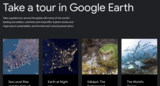
The Earth has thousands of volcanoes dotting its surface. Join Google Earth …
The Earth has thousands of volcanoes dotting its surface. Join Google Earth as we explore some of the most amazing, and dangerous features on our planet.
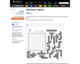
This interactive Flash puzzle helps children develop number sense and an understanding …
This interactive Flash puzzle helps children develop number sense and an understanding of our decimal number system. A 0-99 square has been cut into 11 irregular pieces which the user re-assembles. A printable (pdf) version is included along with questions for Getting Started and a Teachers' Resources page with implementation suggestions.
At Tier 2, schools provide small group, standardized academic, social, emotional, and …
At Tier 2, schools provide small group, standardized academic, social, emotional, and behavioral supports using validated intervention programs. Use this guide to determine if your Tier 2 program is on the right track.
Scaling personalized learning at the district level may seem like a daunting …
Scaling personalized learning at the district level may seem like a daunting task, and it is. But when the right conditions are put in place, schools can move beyond pockets of excellence to a truly personalized approach for every student. Building a vision with district stakeholders and creating a culture of innovation where everyone is encouraged to try new things and learn from failure while ensuring the transparency required for each person to understand their role in pursuing that vision are the foundation for aligning all aspects of the system behind your district's vision for personalized teaching and learning.
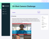
Have you ever noticed? There are common camera composition conventions that professional …
Have you ever noticed? There are common camera composition conventions that professional news video shooters, cinematographers, and broadcast engineers use to appeal to viewers. With this 10-Shot Camera Challenge, students can practice and hone basic camera composition shots.
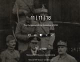
Story Map which provides a short overview of WWI, its origins, trench …
Story Map which provides a short overview of WWI, its origins, trench warfare, the armistice, and remembrance, including the creation of Veteran's Day.
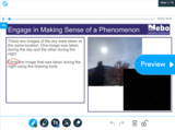
This is an interactive, first-grade Nearpod lesson tied to SEEd standard 1.1.1. …
This is an interactive, first-grade Nearpod lesson tied to SEEd standard 1.1.1. It guides students through information and activities about the movement of the Sun, Moon, and stars. This resource is a student-ready, three-dimensional SEEd science lesson you can add to your Nearpod library. Many of the phenomena, text, and images come from UEN OER textbooks, Seedstorylines.org, ck12.org, and pixabay.com. Most videos are from youtube.com or pbslearningmedia.org. Many of the simulations were found at phet.colorado.edu, ck12.org, and pbslearningmedia.org. This lesson is unique to Nebo School District but was built with the help of many amazing ideas from teachers throughout Utah.
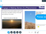
This is an interactive, first-grade Nearpod lesson tied to SEEd standard 1.1.1. …
This is an interactive, first-grade Nearpod lesson tied to SEEd standard 1.1.1. It guides students through information and activities about the pattern of sunrise and sunset. This resource is a student-ready, three-dimensional SEEd science lesson you can add to your Nearpod library. Many of the phenomena, text, and images come from UEN OER textbooks, Seedstorylines.org, ck12.org, and pixabay.com. Most videos are from youtube.com or pbslearningmedia.org. Many of the simulations were found at phet.colorado.edu, ck12.org, and pbslearningmedia.org. This lesson is unique to Nebo School District but was built with the help of many amazing ideas from teachers throughout Utah.
This is a first-grade student science experience tied to SEEd standard 1.1.1. …
This is a first-grade student science experience tied to SEEd standard 1.1.1. In this experience students obtain and communicate information about the patterns of movement of the Sun and stars. These experiences were designed to support students in engaging in science investigations with siblings and/or parents at home and then report back about what was discovered. They were created in a way that is easily adaptable for both online and printed formats. They are formatted to help students wonder about and investigate the science phenomena happening in the world around them. These experiences do not describe how students should write up and return work to their teacher. It is up to each teacher to adapt them to best meet student needs. When individualized by the teacher, a student could be asked to engage in one or more of these experiences a week and report back. This format aligns closely to the vision and expectation of the SEEd standards.
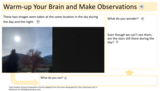
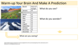
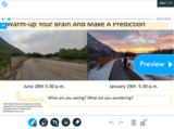
This is a first-grade student science experience tied to SEEd standard 1.1.2. …
This is a first-grade student science experience tied to SEEd standard 1.1.2. In this experience students make connections between daylight hours and seasons. These experiences were designed to support students in engaging in science investigations with siblings and/or parents at home and then report back about what was discovered. They were created in a way that is easily adaptable for both online and printed formats. They are formatted to help students wonder about and investigate the science phenomena happening in the world around them. These experiences do not describe how students should write up and return work to their teacher. It is up to each teacher to adapt them to best meet student needs. When individualized by the teacher, a student could be asked to engage in one or more of these experiences a week and report back. This format aligns closely to the vision and expectation of the SEEd standards.
This is an interactive, first-grade Nearpod lesson tied to SEEd standard 1.1.2. …
This is an interactive, first-grade Nearpod lesson tied to SEEd standard 1.1.2. It guides students through information and activities about the patterns observed in the amount of daylight. This resource is a student-ready, three-dimensional SEEd science lesson you can add to your Nearpod library. Many of the phenomena, text, and images come from UEN OER textbooks, Seedstorylines.org, ck12.org, and pixabay.com. Most videos are from youtube.com or pbslearningmedia.org. Many of the simulations were found at phet.colorado.edu, ck12.org, and pbslearningmedia.org. This lesson is unique to Nebo School District but was built with the help of many amazing ideas from teachers throughout Utah.
No restrictions on your remixing, redistributing, or making derivative works. Give credit to the author, as required.
Your remixing, redistributing, or making derivatives works comes with some restrictions, including how it is shared.
Your redistributing comes with some restrictions. Do not remix or make derivative works.
Most restrictive license type. Prohibits most uses, sharing, and any changes.
Copyrighted materials, available under Fair Use and the TEACH Act for US-based educators, or other custom arrangements. Go to the resource provider to see their individual restrictions.