Water consists of a chemical compound formed between two hydrogen atoms and …
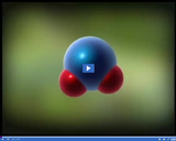
Water consists of a chemical compound formed between two hydrogen atoms and one oxygen atom. The atoms are connected to one another via a covalent bond.
Watch water boil at room temperature. The temperature at which water boils …
Watch water boil at room temperature. The temperature at which water boils depends on pressure. You can demonstrate this by dramatically lowering the pressure on a water-filled plastic syringe at room temperature.
Water is a limited resource that we use over and over again. …
Water is a limited resource that we use over and over again. The idea is to teach the science behind the water cycle, where water comes from and is located on the Earth. After research and developing and understanding of conservation students will create a water tower that will collect and store rainwater. Students will also create a Public Service Announcement (PSA) on water conservation.
When water utility personnel recognized their groundwater withdrawals were damaging ecosystems in …
When water utility personnel recognized their groundwater withdrawals were damaging ecosystems in the Tampa Bay area, they found new ways to reduce their dependence on it.
This article lists common misconceptions about states and changes of matter and …
This article lists common misconceptions about states and changes of matter and the water cycle. It provides formative assessment probes and information about teaching for conceptual change.
This article describes six collaborative and real data projects that engage elementary …
This article describes six collaborative and real data projects that engage elementary students in collecting and sharing local data and communicating with students across the country and world.
This article from the free online magazine Beyond Weather and the Water …
This article from the free online magazine Beyond Weather and the Water Cycle provides appropriate science lessons for Grades K-5. The focus is on acquainting young learners with climate-change concepts that are not too complex for their grade level and will not frighten them. In each issue, the magazine develops articles around one of the seven essential principles of climate science. The author believes early lessons about water availability and extreme weather events will prepare students for complex climate concepts they will encounter in later grades.
In the growing season, farmers and ranchers keep a watchful eye for …
In the growing season, farmers and ranchers keep a watchful eye for any sign of drought. Early warning information can increase their range of options for dealing with the lack of water.
This article aligns the concepts of Essential Principle 2 of the Climate …
This article aligns the concepts of Essential Principle 2 of the Climate Sciences to the K-5 content standards of the National Science Education Standards. The author also identifies common misconceptions about heat and the greenhouse gases effect and offers resources for assessing students' understanding of interactions among components of the Earth system. This article continues the examination of the climate sciences and climate literacy on which the online magazine Beyond Weather and the Water Cycle is structured.
This article identifies age-appropriate national science education content standards and curriculum connections …
This article identifies age-appropriate national science education content standards and curriculum connections for introducing complex concepts contained in Principle 7 of the Essential Principles of Climate Sciences. The principle describes consequences of climate changes on Earth systems and human lives. The content standards will help teachers determine appropriate topics for their students. A number of resources from the online magazine Beyond Weather and the Water Cycle are highlighted for their connection to the science curriculum in the early grades. In addition, the article identifies common misconceptions about weather and the water cycle often held by students.
When you add water to effervescent (fizzy) tablets or baking powder, bubbles …
When you add water to effervescent (fizzy) tablets or baking powder, bubbles are formed: a gas is produced. You can use this gas to inflate a balloon without blowing it up yourself. What kind of gas is it? Let us collect this gas and analyse it through experiments.
Explore pressure in the atmosphere and underwater. Reshape a pipe to see …
Explore pressure in the atmosphere and underwater. Reshape a pipe to see how it changes fluid flow speed. Experiment with a leaky water tower to see how the height and water level determine the water trajectory.
This article provides science content knowledge about forces that shape the Earth's …
This article provides science content knowledge about forces that shape the Earth's surface: erosion by wind, water, and ice, volcanoes, earthquakes, and plate tectonics and how these forces affect Earth's polar regions.
The significance of -- Flooding hazards in Utah -- is discussed in …
The significance of -- Flooding hazards in Utah -- is discussed in this media item extracted from the 22-part video series THE GEOGRAPHY OF UTAH, conceived and written by Albert L. Fisher, PhD (University of Utah). The series encompasses the political, cultural, historical and sociological geography of the state of Utah. It describes the activities, the land and the people. Much of the video material was videotaped on location throughout the state of Utah, giving the student and interested viewer valuable field trip experiences.
A view of -- Lake Powell -- is presented in this media …
A view of -- Lake Powell -- is presented in this media item extracted from the 22-part video series THE GEOGRAPHY OF UTAH, conceived and written by Albert L. Fisher, PhD (University of Utah). The series encompasses the political, cultural, historical and sociological geography of the state of Utah. It describes the activities, the land and the people. Much of the video material was videotaped on location throughout the state of Utah, giving the student and interested viewer valuable field trip experiences. === This is a view from the bridge at Hite's Crossing. ===
A view of -- Wasatch Front and Utah Lake -- is presented …
A view of -- Wasatch Front and Utah Lake -- is presented in this media item extracted from the 22-part video series THE GEOGRAPHY OF UTAH, conceived and written by Albert L. Fisher, PhD (University of Utah). The series encompasses the political, cultural, historical and sociological geography of the state of Utah. It describes the activities, the land and the people. Much of the video material was videotaped on location throughout the state of Utah, giving the student and interested viewer valuable field trip experiences.
No restrictions on your remixing, redistributing, or making derivative works. Give credit to the author, as required.
Your remixing, redistributing, or making derivatives works comes with some restrictions, including how it is shared.
Your redistributing comes with some restrictions. Do not remix or make derivative works.
Most restrictive license type. Prohibits most uses, sharing, and any changes.
Copyrighted materials, available under Fair Use and the TEACH Act for US-based educators, or other custom arrangements. Go to the resource provider to see their individual restrictions.