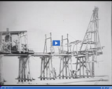
The significance of -- Original Lucin Cutoff -- is discussed in this …
The significance of -- Original Lucin Cutoff -- is discussed in this media item extracted from the 22-part video series THE GEOGRAPHY OF UTAH, conceived and written by Albert L. Fisher, PhD (University of Utah). The series encompasses the political, cultural, historical and sociological geography of the state of Utah. It describes the activities, the land and the people. Much of the video material was videotaped on location throughout the state of Utah, giving the student and interested viewer valuable field trip experiences. === In 1903, the railroad built a wooden trestle, called the Lucin Cutoff, to save time and mileage by establishing a direct route across the lake. But salt encrusted the wood piles and the cutoff became a rickety fire hazard. ===
The significance of -- Provo Terrace receding to Stansbury Terrace -- is …
The significance of -- Provo Terrace receding to Stansbury Terrace -- is discussed in this media item extracted from the 22-part video series THE GEOGRAPHY OF UTAH, conceived and written by Albert L. Fisher, PhD (University of Utah). The series encompasses the political, cultural, historical and sociological geography of the state of Utah. It describes the activities, the land and the people. Much of the video material was videotaped on location throughout the state of Utah, giving the student and interested viewer valuable field trip experiences. === The gradual warming of the earth increased evaporation and decreased precipitation, causing the lake level to drop another 300 feet from the Provo level, where it stabilized at the Stansbury level. ===
The significance of -- Reconstruction of railroad causeway -- is discussed in …
The significance of -- Reconstruction of railroad causeway -- is discussed in this media item extracted from the 22-part video series THE GEOGRAPHY OF UTAH, conceived and written by Albert L. Fisher, PhD (University of Utah). The series encompasses the political, cultural, historical and sociological geography of the state of Utah. It describes the activities, the land and the people. Much of the video material was videotaped on location throughout the state of Utah, giving the student and interested viewer valuable field trip experiences. === In 1956, the Southern Pacific Railroad built an earthen causeway to replace the Lucin Cutoff. The causeway, 450 feet wide at the base and 35 feet wide at the top, required one of the largest earth-moving projects in history. Built into the causeway were several openings to allow lake water to pass from one side to another. The openings proved to be too small, and the causeway effectively stopped north-south lake circulation. Since 90 percent of the fresh water entering the Great Salt Lake is south of the causeway, the northern arm of the lake was 20 to 25 percent saltier than the southern arm. ===
A view of -- Saltair reopened, 1929 -- is presented in this …
A view of -- Saltair reopened, 1929 -- is presented in this media item extracted from the 22-part video series THE GEOGRAPHY OF UTAH, conceived and written by Albert L. Fisher, PhD (University of Utah). The series encompasses the political, cultural, historical and sociological geography of the state of Utah. It describes the activities, the land and the people. Much of the video material was videotaped on location throughout the state of Utah, giving the student and interested viewer valuable field trip experiences.
A view of -- Saltair Resort, 1950s -- is presented in this …
A view of -- Saltair Resort, 1950s -- is presented in this media item extracted from the 22-part video series THE GEOGRAPHY OF UTAH, conceived and written by Albert L. Fisher, PhD (University of Utah). The series encompasses the political, cultural, historical and sociological geography of the state of Utah. It describes the activities, the land and the people. Much of the video material was videotaped on location throughout the state of Utah, giving the student and interested viewer valuable field trip experiences. === By the 1950s, the Great Salt Lake had receded far from Saltair's pier, and the resort was closed. ===
The significance of -- Saltair Resort, 1990s -- is discussed in this …
The significance of -- Saltair Resort, 1990s -- is discussed in this media item extracted from the 22-part video series THE GEOGRAPHY OF UTAH, conceived and written by Albert L. Fisher, PhD (University of Utah). The series encompasses the political, cultural, historical and sociological geography of the state of Utah. It describes the activities, the land and the people. Much of the video material was videotaped on location throughout the state of Utah, giving the student and interested viewer valuable field trip experiences.
The significance of -- Salt plant, Great Salt Lake southern shore -- …
The significance of -- Salt plant, Great Salt Lake southern shore -- is discussed in this media item extracted from the 22-part video series THE GEOGRAPHY OF UTAH, conceived and written by Albert L. Fisher, PhD (University of Utah). The series encompasses the political, cultural, historical and sociological geography of the state of Utah. It describes the activities, the land and the people. Much of the video material was videotaped on location throughout the state of Utah, giving the student and interested viewer valuable field trip experiences.
A view of -- Satellite photo of Great Salt Lake -- is …
A view of -- Satellite photo of Great Salt Lake -- is presented in this media item extracted from the 22-part video series THE GEOGRAPHY OF UTAH, conceived and written by Albert L. Fisher, PhD (University of Utah). The series encompasses the political, cultural, historical and sociological geography of the state of Utah. It describes the activities, the land and the people. Much of the video material was videotaped on location throughout the state of Utah, giving the student and interested viewer valuable field trip experiences. === Since 90 percent of the fresh water entering the Great Salt Lake is south of the causeway, the northern arm of the lake was 20 to 25 percent saltier than the southern arm. The difference can be seen on this satellite photo of the Great Salt Lake. The northern, and more salty side, is light blue. ===
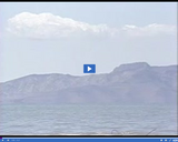
The significance of -- Stansbury Island -- is discussed in this media …
The significance of -- Stansbury Island -- is discussed in this media item extracted from the 22-part video series THE GEOGRAPHY OF UTAH, conceived and written by Albert L. Fisher, PhD (University of Utah). The series encompasses the political, cultural, historical and sociological geography of the state of Utah. It describes the activities, the land and the people. Much of the video material was videotaped on location throughout the state of Utah, giving the student and interested viewer valuable field trip experiences. === Stansbury Island, the second largest island in the Great Salt Lake, was named after Captain Howard Stansbury, the first man to survey the lake. When the lake level is low, Stansbury Island becomes a peninsula. ===
A view of -- Stansbury Island -- is presented in this media …
A view of -- Stansbury Island -- is presented in this media item extracted from the 22-part video series THE GEOGRAPHY OF UTAH, conceived and written by Albert L. Fisher, PhD (University of Utah). The series encompasses the political, cultural, historical and sociological geography of the state of Utah. It describes the activities, the land and the people. Much of the video material was videotaped on location throughout the state of Utah, giving the student and interested viewer valuable field trip experiences.
The significance of -- Try to Sink buoy at Saltair, 1893 -- …
The significance of -- Try to Sink buoy at Saltair, 1893 -- is discussed in this media item extracted from the 22-part video series THE GEOGRAPHY OF UTAH, conceived and written by Albert L. Fisher, PhD (University of Utah). The series encompasses the political, cultural, historical and sociological geography of the state of Utah. It describes the activities, the land and the people. Much of the video material was videotaped on location throughout the state of Utah, giving the student and interested viewer valuable field trip experiences. === Try to sink, the sign said at the 1893 Saltair resort. People were fascinated by the Great Salt Lake's incredible buoyancy, due to the salt content. ===
The significance of -- Salt Lake and Wasatch Front features -- is …
The significance of -- Salt Lake and Wasatch Front features -- is discussed in this media item extracted from the 22-part video series THE GEOGRAPHY OF UTAH, conceived and written by Albert L. Fisher, PhD (University of Utah). The series encompasses the political, cultural, historical and sociological geography of the state of Utah. It describes the activities, the land and the people. Much of the video material was videotaped on location throughout the state of Utah, giving the student and interested viewer valuable field trip experiences.
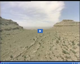
The significance of Canyonlands physiographic subregion is discussed in this media item …
The significance of Canyonlands physiographic subregion is discussed in this media item extracted from the 22-part video series THE GEOGRAPHY OF UTAH, conceived and written by Albert L. Fisher, PhD (University of Utah). The series encompasses the political, cultural, historical and sociological geography of the state of Utah. It describes the activities, the land and the people. Much of the video material was videotaped on location throughout the state of Utah, giving the student and interested viewer valuable field trip experiences.
A view of -- Deadhorse Point -- is presented in this media …
A view of -- Deadhorse Point -- is presented in this media item extracted from the 22-part video series THE GEOGRAPHY OF UTAH, conceived and written by Albert L. Fisher, PhD (University of Utah). The series encompasses the political, cultural, historical and sociological geography of the state of Utah. It describes the activities, the land and the people. Much of the video material was videotaped on location throughout the state of Utah, giving the student and interested viewer valuable field trip experiences.
The significance of -- Deer Creek Reservoir and Mount Tempanogos -- is …
The significance of -- Deer Creek Reservoir and Mount Tempanogos -- is discussed in this media item extracted from the 22-part video series THE GEOGRAPHY OF UTAH, conceived and written by Albert L. Fisher, PhD (University of Utah). The series encompasses the political, cultural, historical and sociological geography of the state of Utah. It describes the activities, the land and the people. Much of the video material was videotaped on location throughout the state of Utah, giving the student and interested viewer valuable field trip experiences. === Mount Timpanogos is 11,750 feet at its highest peak, rising above Deer Creek Reservoir along Provo Canyon. ===
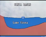
The significance of "Diagram of Lake Uintah" is discussed in this media …
The significance of "Diagram of Lake Uintah" is discussed in this media item extracted from the 22-part video series THE GEOGRAPHY OF UTAH, conceived and written by Albert L. Fisher, PhD (University of Utah). The series encompasses the political, cultural, historical and sociological geography of the state of Utah. It describes the activities, the land and the people. Much of the video material was videotaped on location throughout the state of Utah, giving the student and interested viewer valuable field trip experiences. Lake Uintah covered the Uintah Basin thousands of years ago; stratified sediments were deposited, filling the great bowl of the syncline.
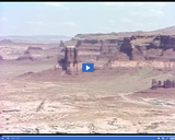
The significance of -- Lake Powell, from Hite's Crossing -- is discussed …
The significance of -- Lake Powell, from Hite's Crossing -- is discussed in this media item extracted from the 22-part video series THE GEOGRAPHY OF UTAH, conceived and written by Albert L. Fisher, PhD (University of Utah). The series encompasses the political, cultural, historical and sociological geography of the state of Utah. It describes the activities, the land and the people. Much of the video material was videotaped on location throughout the state of Utah, giving the student and interested viewer valuable field trip experiences. === Viewed from Hite's Crossing, east view of sedimentary rock layers. ===
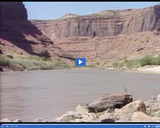
The significance of -- Colorado River -- is discussed in this media …
The significance of -- Colorado River -- is discussed in this media item extracted from the 22-part video series THE GEOGRAPHY OF UTAH, conceived and written by Albert L. Fisher, PhD (University of Utah). The series encompasses the political, cultural, historical and sociological geography of the state of Utah. It describes the activities, the land and the people. Much of the video material was videotaped on location throughout the state of Utah, giving the student and interested viewer valuable field trip experiences. === Viewed from canyon northeast of Moab. ===
A view of -- Flaming Gorge Dam -- is presented in this …
A view of -- Flaming Gorge Dam -- is presented in this media item extracted from the 22-part video series THE GEOGRAPHY OF UTAH, conceived and written by Albert L. Fisher, PhD (University of Utah). The series encompasses the political, cultural, historical and sociological geography of the state of Utah. It describes the activities, the land and the people. Much of the video material was videotaped on location throughout the state of Utah, giving the student and interested viewer valuable field trip experiences.
The significance of -- Great Salt Lake with islands -- is discussed …
The significance of -- Great Salt Lake with islands -- is discussed in this media item extracted from the 22-part video series THE GEOGRAPHY OF UTAH, conceived and written by Albert L. Fisher, PhD (University of Utah). The series encompasses the political, cultural, historical and sociological geography of the state of Utah. It describes the activities, the land and the people. Much of the video material was videotaped on location throughout the state of Utah, giving the student and interested viewer valuable field trip experiences.
No restrictions on your remixing, redistributing, or making derivative works. Give credit to the author, as required.
Your remixing, redistributing, or making derivatives works comes with some restrictions, including how it is shared.
Your redistributing comes with some restrictions. Do not remix or make derivative works.
Most restrictive license type. Prohibits most uses, sharing, and any changes.
Copyrighted materials, available under Fair Use and the TEACH Act for US-based educators, or other custom arrangements. Go to the resource provider to see their individual restrictions.