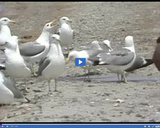
The significance of -- Brine shrimp in the Great Salt Lake -- …
The significance of -- Brine shrimp in the Great Salt Lake -- is discussed in this media item extracted from the 22-part video series THE GEOGRAPHY OF UTAH, conceived and written by Albert L. Fisher, PhD (University of Utah). The series encompasses the political, cultural, historical and sociological geography of the state of Utah. It describes the activities, the land and the people. Much of the video material was videotaped on location throughout the state of Utah, giving the student and interested viewer valuable field trip experiences. === The tiny brine shrimp, which feed on the several varieties of algae growing in the lake, are harvested for tropical fish food. ===
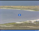
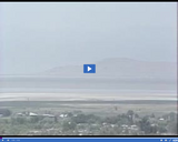
A view of -- Carrington Island -- is presented in this media …
A view of -- Carrington Island -- is presented in this media item extracted from the 22-part video series THE GEOGRAPHY OF UTAH, conceived and written by Albert L. Fisher, PhD (University of Utah). The series encompasses the political, cultural, historical and sociological geography of the state of Utah. It describes the activities, the land and the people. Much of the video material was videotaped on location throughout the state of Utah, giving the student and interested viewer valuable field trip experiences.
The significance of -- Changing lake levels -- is discussed in this …
The significance of -- Changing lake levels -- is discussed in this media item extracted from the 22-part video series THE GEOGRAPHY OF UTAH, conceived and written by Albert L. Fisher, PhD (University of Utah). The series encompasses the political, cultural, historical and sociological geography of the state of Utah. It describes the activities, the land and the people. Much of the video material was videotaped on location throughout the state of Utah, giving the student and interested viewer valuable field trip experiences.
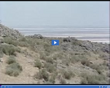
A view of -- Changing lake levels -- is presented in this …
A view of -- Changing lake levels -- is presented in this media item extracted from the 22-part video series THE GEOGRAPHY OF UTAH, conceived and written by Albert L. Fisher, PhD (University of Utah). The series encompasses the political, cultural, historical and sociological geography of the state of Utah. It describes the activities, the land and the people. Much of the video material was videotaped on location throughout the state of Utah, giving the student and interested viewer valuable field trip experiences.
The significance of -- "City of Corinne" at Lake Park Resort -- …
The significance of -- "City of Corinne" at Lake Park Resort -- is discussed in this media item extracted from the 22-part video series THE GEOGRAPHY OF UTAH, conceived and written by Albert L. Fisher, PhD (University of Utah). The series encompasses the political, cultural, historical and sociological geography of the state of Utah. It describes the activities, the land and the people. Much of the video material was videotaped on location throughout the state of Utah, giving the student and interested viewer valuable field trip experiences.
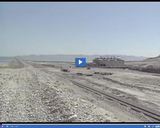
The significance of -- Evaporation ponds and dikes of salt plant -- …
The significance of -- Evaporation ponds and dikes of salt plant -- is discussed in this media item extracted from the 22-part video series THE GEOGRAPHY OF UTAH, conceived and written by Albert L. Fisher, PhD (University of Utah). The series encompasses the political, cultural, historical and sociological geography of the state of Utah. It describes the activities, the land and the people. Much of the video material was videotaped on location throughout the state of Utah, giving the student and interested viewer valuable field trip experiences. === Salt, magnesium chloride, sodium sulphate, potash, and lithium are all part of the Great Salt Lake. It is a natural repository for minerals. The ground and surface waters that feed the lake add about two million tons of dissolved solids to the lake each year. The billions of tons of solids found in the lake brine and the salt flats along the shore make the Great Salt Lake the site of the largest mineral deposits in Utah. ===
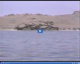
The significance of -- Fremont Island -- is discussed in this media …
The significance of -- Fremont Island -- is discussed in this media item extracted from the 22-part video series THE GEOGRAPHY OF UTAH, conceived and written by Albert L. Fisher, PhD (University of Utah). The series encompasses the political, cultural, historical and sociological geography of the state of Utah. It describes the activities, the land and the people. Much of the video material was videotaped on location throughout the state of Utah, giving the student and interested viewer valuable field trip experiences. === Viewed from the Great Salt Lake. Fremont Island, named after Captain John Fremont, is famous for the Native American artifacts that have been discovered on its slopes. It is also the site of Kit Carson's cross. Carson, a member of Fremont's expedition, chiseled the cross on a rock outcropping at the island's summit. ===
A view of -- Fremont Island -- is presented in this media …
A view of -- Fremont Island -- is presented in this media item extracted from the 22-part video series THE GEOGRAPHY OF UTAH, conceived and written by Albert L. Fisher, PhD (University of Utah). The series encompasses the political, cultural, historical and sociological geography of the state of Utah. It describes the activities, the land and the people. Much of the video material was videotaped on location throughout the state of Utah, giving the student and interested viewer valuable field trip experiences.
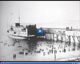
A view of -- Garfield Resort, 1881 -- is presented in this …
A view of -- Garfield Resort, 1881 -- is presented in this media item extracted from the 22-part video series THE GEOGRAPHY OF UTAH, conceived and written by Albert L. Fisher, PhD (University of Utah). The series encompasses the political, cultural, historical and sociological geography of the state of Utah. It describes the activities, the land and the people. Much of the video material was videotaped on location throughout the state of Utah, giving the student and interested viewer valuable field trip experiences.
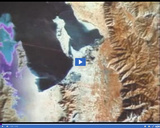
The significance of -- Great Salt Lake -- is discussed in this …
The significance of -- Great Salt Lake -- is discussed in this media item extracted from the 22-part video series THE GEOGRAPHY OF UTAH, conceived and written by Albert L. Fisher, PhD (University of Utah). The series encompasses the political, cultural, historical and sociological geography of the state of Utah. It describes the activities, the land and the people. Much of the video material was videotaped on location throughout the state of Utah, giving the student and interested viewer valuable field trip experiences. === Viewed from Wasatch Mountains. Today, what remains of Lake Bonneville is the Great Salt Lake, a shallow lake located at the bottom of the Bonneville Basin. At 4,200 feet above sea level, the lake averages only 13 feet in depth. The highest lake level in modern times, recorded in 1873, was 4,212 feet above sea level. The lowest level, recorded in 1964, was 4,192 feet. But since the lake has a gentle slope, a small difference in lake level makes a big difference in the area the lake covers. In 1873, for example, the lake covered 2,250 square miles. It normally covers between 1,100 and 1,500 square miles. Yet, the average depth has fluctuated within a range of only 20 feet. ===
The significance of -- Great Salt Lake, images -- is discussed in …
The significance of -- Great Salt Lake, images -- is discussed in this media item extracted from the 22-part video series THE GEOGRAPHY OF UTAH, conceived and written by Albert L. Fisher, PhD (University of Utah). The series encompasses the political, cultural, historical and sociological geography of the state of Utah. It describes the activities, the land and the people. Much of the video material was videotaped on location throughout the state of Utah, giving the student and interested viewer valuable field trip experiences.
The significance of -- Great Salt Lake pumping project, 1986-87 -- is …
The significance of -- Great Salt Lake pumping project, 1986-87 -- is discussed in this media item extracted from the 22-part video series THE GEOGRAPHY OF UTAH, conceived and written by Albert L. Fisher, PhD (University of Utah). The series encompasses the political, cultural, historical and sociological geography of the state of Utah. It describes the activities, the land and the people. Much of the video material was videotaped on location throughout the state of Utah, giving the student and interested viewer valuable field trip experiences.
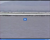
A view of -- Interstate 80 during high water levels -- is …
A view of -- Interstate 80 during high water levels -- is presented in this media item extracted from the 22-part video series THE GEOGRAPHY OF UTAH, conceived and written by Albert L. Fisher, PhD (University of Utah). The series encompasses the political, cultural, historical and sociological geography of the state of Utah. It describes the activities, the land and the people. Much of the video material was videotaped on location throughout the state of Utah, giving the student and interested viewer valuable field trip experiences.
A view of -- Kit Carson's cross -- is presented in this …
A view of -- Kit Carson's cross -- is presented in this media item extracted from the 22-part video series THE GEOGRAPHY OF UTAH, conceived and written by Albert L. Fisher, PhD (University of Utah). The series encompasses the political, cultural, historical and sociological geography of the state of Utah. It describes the activities, the land and the people. Much of the video material was videotaped on location throughout the state of Utah, giving the student and interested viewer valuable field trip experiences. === Fremont Island, is the site of Kit Carson's cross. Carson, a member of Captain John Fremont's expedition, chiseled the cross on a rock outcropping at the island's summit. ===
A view of -- Lake Bonneville -- is presented in this media …
A view of -- Lake Bonneville -- is presented in this media item extracted from the 22-part video series THE GEOGRAPHY OF UTAH, conceived and written by Albert L. Fisher, PhD (University of Utah). The series encompasses the political, cultural, historical and sociological geography of the state of Utah. It describes the activities, the land and the people. Much of the video material was videotaped on location throughout the state of Utah, giving the student and interested viewer valuable field trip experiences. === At its greatest extent, Lake Bonneville was 346 miles long and 145 miles wide. It covered 20,000 square miles and was over 1,000 feet deep. Lake Bonneville was nearly as large as today's Lake Michigan. The large blue segment on the map shows today's Great Salt Lake. ===
A view of -- Lake Bonneville with Red Rock Pass -- is …
A view of -- Lake Bonneville with Red Rock Pass -- is presented in this media item extracted from the 22-part video series THE GEOGRAPHY OF UTAH, conceived and written by Albert L. Fisher, PhD (University of Utah). The series encompasses the political, cultural, historical and sociological geography of the state of Utah. It describes the activities, the land and the people. Much of the video material was videotaped on location throughout the state of Utah, giving the student and interested viewer valuable field trip experiences. === The water of Lake Bonneville eventually reached the rim of Red Rock Pass in northern Cache Valley and began to overflow, causing a dramatic geologic event. Red Rock Pass consisted of loose sand and gravel. Escaping water washed away this material, deepening the channel and causing the water overflow to increase rapidly. The flow of water through the Pass is estimated to have been three or four times the amount of water flowing through today's Amazon River. Red Rock Pass continued to erode for about 25 years until the water reached a layer of resistant limestone, and the lake stabilized at the Provo level, about 400 feet lower. ===
The significance of -- Lake Effect -- is discussed in this media …
The significance of -- Lake Effect -- is discussed in this media item extracted from the 22-part video series THE GEOGRAPHY OF UTAH, conceived and written by Albert L. Fisher, PhD (University of Utah). The series encompasses the political, cultural, historical and sociological geography of the state of Utah. It describes the activities, the land and the people. Much of the video material was videotaped on location throughout the state of Utah, giving the student and interested viewer valuable field trip experiences. === Air masses passing over the lake from the west evaporate lake water. The air becomes unstable, and as the air masses converge on a narrow belt of land east of the lake, usually between Davis County and the Salt Lake valley, heavy amounts of rain or snow can fall in a short period of time. The phenomenon is referred to as the "Lake Effect," and its precipitation is usually confined to a small area. ===
The significance of -- Lake Park Resort -- is discussed in this …
The significance of -- Lake Park Resort -- is discussed in this media item extracted from the 22-part video series THE GEOGRAPHY OF UTAH, conceived and written by Albert L. Fisher, PhD (University of Utah). The series encompasses the political, cultural, historical and sociological geography of the state of Utah. It describes the activities, the land and the people. Much of the video material was videotaped on location throughout the state of Utah, giving the student and interested viewer valuable field trip experiences. === Lake Park, built in 1886, had pavilions, piers, bathhouses, and even a train. ===
A view of -- Lake Side Resort -- is presented in this …
A view of -- Lake Side Resort -- is presented in this media item extracted from the 22-part video series THE GEOGRAPHY OF UTAH, conceived and written by Albert L. Fisher, PhD (University of Utah). The series encompasses the political, cultural, historical and sociological geography of the state of Utah. It describes the activities, the land and the people. Much of the video material was videotaped on location throughout the state of Utah, giving the student and interested viewer valuable field trip experiences. === Built in 1870. ===
The significance of -- Mineral deposits on Great Salt Lake shores -- …
The significance of -- Mineral deposits on Great Salt Lake shores -- is discussed in this media item extracted from the 22-part video series THE GEOGRAPHY OF UTAH, conceived and written by Albert L. Fisher, PhD (University of Utah). The series encompasses the political, cultural, historical and sociological geography of the state of Utah. It describes the activities, the land and the people. Much of the video material was videotaped on location throughout the state of Utah, giving the student and interested viewer valuable field trip experiences. === Salt, magnesium chloride, sodium sulphate, potash, and lithium are all part of the Great Salt Lake. It is a natural repository for minerals. The ground and surface waters that feed the lake add about two million tons of dissolved solids to the lake each year. The billions of tons of solids found in the lake brine and the salt flats along the shore make the Great Salt Lake the site of the largest mineral deposits in Utah. ===
No restrictions on your remixing, redistributing, or making derivative works. Give credit to the author, as required.
Your remixing, redistributing, or making derivatives works comes with some restrictions, including how it is shared.
Your redistributing comes with some restrictions. Do not remix or make derivative works.
Most restrictive license type. Prohibits most uses, sharing, and any changes.
Copyrighted materials, available under Fair Use and the TEACH Act for US-based educators, or other custom arrangements. Go to the resource provider to see their individual restrictions.