An image of -- Bigtooth maple, floral structure -- is provided, drawn …
An image of -- Bigtooth maple, floral structure -- is provided, drawn from the the collection of UTAH NATIVE PLANTS, contributed by the Red Butte Garden and Arboretum, Unviersity of Utah. The photographs show the changing appearance of various plants throughout the seasons. === Bigtooth maple (Acer grandidentatum) is often found along streams and in drainages in the foothill region. 'Bigtooth' refers to the leaves of these trees which are deeply lobed. It is also called canyon maple or western sugar maple. In the fall, the leaves are very colorful. Deer and livestock eat the twigs and leaves. Native people used bigtooth maple for flavoring. ===
An image of -- Bigtooth maple, hillside -- is provided, drawn from …
An image of -- Bigtooth maple, hillside -- is provided, drawn from the the collection of UTAH NATIVE PLANTS, contributed by the Red Butte Garden and Arboretum, Unviersity of Utah. The photographs show the changing appearance of various plants throughout the seasons. === Bigtooth maple (Acer grandidentatum) is often found along streams and in drainages in the foothill region. 'Bigtooth' refers to the leaves of these trees which are deeply lobed. It is also called canyon maple or western sugar maple. In the fall, the leaves are very colorful. Deer and livestock eat the twigs and leaves. Native people used bigtooth maple for flavoring. ===
An image of -- Bigtooth maple, red leaves -- is provided, drawn …
An image of -- Bigtooth maple, red leaves -- is provided, drawn from the the collection of UTAH NATIVE PLANTS, contributed by the Red Butte Garden and Arboretum, Unviersity of Utah. The photographs show the changing appearance of various plants throughout the seasons. === Bigtooth maple (Acer grandidentatum) is often found along streams and in drainages in the foothill region. 'Bigtooth' refers to the leaves of these trees which are deeply lobed. It is also called canyon maple or western sugar maple. In the fall, the leaves are very colorful. Deer and livestock eat the twigs and leaves. Native people used bigtooth maple for flavoring. ===
An image of -- Bitterbrush -- is provided, drawn from the the …
An image of -- Bitterbrush -- is provided, drawn from the the collection of UTAH NATIVE PLANTS, contributed by the Red Butte Garden and Arboretum, Unviersity of Utah. The photographs show the changing appearance of various plants throughout the seasons. === Bitterbrush (Purshia tridentata) has small, silvery leaves adapted for its life on sunny hillsides and rocky slopes at 3500- 9000 feet. It is called the favorite browse of mule deer, and it is also eaten by elk. The seeds are eaten by pocket gophers, chipmunks, and ground squirrels. ===
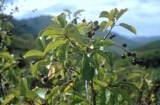
An image of -- Chokecherry -- is provided, drawn from the the …
An image of -- Chokecherry -- is provided, drawn from the the collection of UTAH NATIVE PLANTS, contributed by the Red Butte Garden and Arboretum, Unviersity of Utah. The photographs show the changing appearance of various plants throughout the seasons. === Chokecherry (Prunus virginiana) is usually found along streams or on moist slopes at 4500- 9,000 feet. It is an important food source for many animals, including grouse and bighorn sheep. It was named chokecherry for the bitter taste of the berries, though it has been widely used for jams and juice. ===
An image of -- Chokecherry, with berries -- is provided, drawn from …
An image of -- Chokecherry, with berries -- is provided, drawn from the the collection of UTAH NATIVE PLANTS, contributed by the Red Butte Garden and Arboretum, Unviersity of Utah. The photographs show the changing appearance of various plants throughout the seasons. === Chokecherry (Prunus virginiana) is usually found along streams or on moist slopes at 4500- 9,000 feet. It is an important food source for many animals, including grouse and bighorn sheep. It was named chokecherry for the bitter taste of the berries, though it has been widely used for jams and juice. ===
An image of -- Gambel oak -- is provided, drawn from the …
An image of -- Gambel oak -- is provided, drawn from the the collection of UTAH NATIVE PLANTS, contributed by the Red Butte Garden and Arboretum, Unviersity of Utah. The photographs show the changing appearance of various plants throughout the seasons. === Gambel oak (Quercus gambelii), often called scrub oak, grows at 4500- 7500 feet along the Wasatch Front. This deciduous shrub is often seen in thickets because it grows in clones. It is an important browse for deer. Stellars jays, scrub jays, and rodents feed on its acorns. Acorns were ground and used by native people in bread, soup and pancakes. ===
An image of -- Sagebrush -- is provided, drawn from the the …
An image of -- Sagebrush -- is provided, drawn from the the collection of UTAH NATIVE PLANTS, contributed by the Red Butte Garden and Arboretum, Unviersity of Utah. The photographs show the changing appearance of various plants throughout the seasons. === Sagebrush (Artemesia tridentata ), one of the most abundant shrubs in the west, lives in well-drained soils of sunny, open slopes at 4,500- 10,000 feet. Sagebrush is a shrub, but it has green leaves all year. Every spring additional ephemeral leaves grow on this plant to maximize photosynthesis; they drop off when the weather becomes hotter and drier. Sagebrush leaves have a very strong scent. This plant is eaten by deer and livestock, sage grouse, and many other small animals. ===
An image of -- Western river birch, trunk -- is provided, drawn …
An image of -- Western river birch, trunk -- is provided, drawn from the the collection of UTAH NATIVE PLANTS, contributed by the Red Butte Garden and Arboretum, University of Utah. The photographs show the changing appearance of various plants throughout the seasons. === Western river birch (Betula occidentalis) grows at 5,000- 9,000 feet and is usually found in riparian areas. ===
An image of -- Western river birch in autumn -- is provided, …
An image of -- Western river birch in autumn -- is provided, drawn from the the collection of UTAH NATIVE PLANTS, contributed by the Red Butte Garden and Arboretum, Unviersity of Utah. The photographs show the changing appearance of various plants throughout the seasons. === Western river birch (Betula occidentalis) grows at 5,000- 9,000 feet and is usually found in riparian areas. ===
A view of -- Cactus in bloom, Zion National Park -- is …
A view of -- Cactus in bloom, Zion National Park -- is presented in this media item extracted from the 22-part video series THE GEOGRAPHY OF UTAH, conceived and written by Albert L. Fisher, PhD (University of Utah). The series encompasses the political, cultural, historical and sociological geography of the state of Utah. It describes the activities, the land and the people. Much of the video material was videotaped on location throughout the state of Utah, giving the student and interested viewer valuable field trip experiences.
A view of -- Cattle grazing in grassy meadow -- is presented …
A view of -- Cattle grazing in grassy meadow -- is presented in this media item extracted from the 22-part video series THE GEOGRAPHY OF UTAH, conceived and written by Albert L. Fisher, PhD (University of Utah). The series encompasses the political, cultural, historical and sociological geography of the state of Utah. It describes the activities, the land and the people. Much of the video material was videotaped on location throughout the state of Utah, giving the student and interested viewer valuable field trip experiences.
A view of -- Irrigation sprinklers -- is presented in this media …
A view of -- Irrigation sprinklers -- is presented in this media item extracted from the 22-part video series THE GEOGRAPHY OF UTAH, conceived and written by Albert L. Fisher, PhD (University of Utah). The series encompasses the political, cultural, historical and sociological geography of the state of Utah. It describes the activities, the land and the people. Much of the video material was videotaped on location throughout the state of Utah, giving the student and interested viewer valuable field trip experiences.
A view of -- Little Cottonwood Canyon -- is presented in this …
A view of -- Little Cottonwood Canyon -- is presented in this media item extracted from the 22-part video series THE GEOGRAPHY OF UTAH, conceived and written by Albert L. Fisher, PhD (University of Utah). The series encompasses the political, cultural, historical and sociological geography of the state of Utah. It describes the activities, the land and the people. Much of the video material was videotaped on location throughout the state of Utah, giving the student and interested viewer valuable field trip experiences.
A view of -- Mountain meadow wildflowers -- is presented in this …
A view of -- Mountain meadow wildflowers -- is presented in this media item extracted from the 22-part video series THE GEOGRAPHY OF UTAH, conceived and written by Albert L. Fisher, PhD (University of Utah). The series encompasses the political, cultural, historical and sociological geography of the state of Utah. It describes the activities, the land and the people. Much of the video material was videotaped on location throughout the state of Utah, giving the student and interested viewer valuable field trip experiences. === The flowers pictured are gold fields (left) and penstemon (right). ===
A view of -- Thistle -- is presented in this media item …
A view of -- Thistle -- is presented in this media item extracted from the 22-part video series THE GEOGRAPHY OF UTAH, conceived and written by Albert L. Fisher, PhD (University of Utah). The series encompasses the political, cultural, historical and sociological geography of the state of Utah. It describes the activities, the land and the people. Much of the video material was videotaped on location throughout the state of Utah, giving the student and interested viewer valuable field trip experiences.
A view of -- Carbonville coal train -- is presented in this …
A view of -- Carbonville coal train -- is presented in this media item extracted from the 22-part video series THE GEOGRAPHY OF UTAH, conceived and written by Albert L. Fisher, PhD (University of Utah). The series encompasses the political, cultural, historical and sociological geography of the state of Utah. It describes the activities, the land and the people. Much of the video material was videotaped on location throughout the state of Utah, giving the student and interested viewer valuable field trip experiences. === This is near Price. ===
A view of -- Gilsonite processing plant, Bonanza -- is presented in …
A view of -- Gilsonite processing plant, Bonanza -- is presented in this media item extracted from the 22-part video series THE GEOGRAPHY OF UTAH, conceived and written by Albert L. Fisher, PhD (University of Utah). The series encompasses the political, cultural, historical and sociological geography of the state of Utah. It describes the activities, the land and the people. Much of the video material was videotaped on location throughout the state of Utah, giving the student and interested viewer valuable field trip experiences.
A view of -- Mineral reserves at the Great Salt Lake -- …
A view of -- Mineral reserves at the Great Salt Lake -- is presented in this media item extracted from the 22-part video series THE GEOGRAPHY OF UTAH, conceived and written by Albert L. Fisher, PhD (University of Utah). The series encompasses the political, cultural, historical and sociological geography of the state of Utah. It describes the activities, the land and the people. Much of the video material was videotaped on location throughout the state of Utah, giving the student and interested viewer valuable field trip experiences. === This is mud flats and the northern arm of the Great Salt Lake as seen from the east grade of the Golden Spike National Historic Site. ===
A view of -- Moab Uranium Plant -- is presented in this …
A view of -- Moab Uranium Plant -- is presented in this media item extracted from the 22-part video series THE GEOGRAPHY OF UTAH, conceived and written by Albert L. Fisher, PhD (University of Utah). The series encompasses the political, cultural, historical and sociological geography of the state of Utah. It describes the activities, the land and the people. Much of the video material was videotaped on location throughout the state of Utah, giving the student and interested viewer valuable field trip experiences.
No restrictions on your remixing, redistributing, or making derivative works. Give credit to the author, as required.
Your remixing, redistributing, or making derivatives works comes with some restrictions, including how it is shared.
Your redistributing comes with some restrictions. Do not remix or make derivative works.
Most restrictive license type. Prohibits most uses, sharing, and any changes.
Copyrighted materials, available under Fair Use and the TEACH Act for US-based educators, or other custom arrangements. Go to the resource provider to see their individual restrictions.